
How a lake bank fails around here
Almost every lake in this part of Minnesota sits in glacial till: clay-heavy soil that holds water, softens when it is saturated, and heaves when it freezes. That soil is the reason banks here fail the way they do. Four things do most of the damage, and they usually work together.
- Wave action. Wind across open water throws waves at the same strip of bank all summer. On a lake with a long open reach, the toe of the slope gets cut back a little at a time until the soil above it has nothing to sit on and slumps into the water.
- Ice push. When the ice sheet expands and shifts in late winter, it shoves against the shore with real force. It can heave loose rock, fold sod over on itself, and lift a small wall off its base. Rock that is graded, keyed into the bank, and sitting on a proper slope rides that out. Loose decorative rock does not.
- Runoff. Water off the roof, the driveway, and the lawn collects into a low spot and runs straight down the bank to the lake. Each storm cuts the channel a little deeper. Clay sheds water fast, so a small yard can move a surprising amount of it.
- Bare slopes. A bank that has been stripped, mowed to the edge, or freshly cut for a new home has no roots holding it. Clay till on a bare slope sloughs off in sheets after a wet week, and it does not stop on its own.
Riprap, boulder walls, or plantings: which one fits your bank
There are three honest answers to a failing bank, and the right one depends on the slope, the wave exposure, and how much soil has to be held. We will tell you which one we think fits before we quote anything.
- Riprap fits a bank with active wave or ice erosion where the slope can be laid back to about 3-to-1 (three feet out for every foot up) or flatter. Graded natural fieldstone over a filter layer absorbs the wave and lets water drain through instead of building pressure behind it. It is the workhorse fix for most lake lots in Wright and Meeker County, and when it stays inside the DNR's standard limits it usually does not need a state permit.
- A boulder wall fits a bank that is too steep to lay back, where the house, a shed, or a boathouse sits close to the water and the hillside has to be held nearly vertical. Large boulders stacked with a lean back into the slope carry that load. On most jobs the wall sits above the riprap rather than in place of it, because the toe still needs rock at the waterline.
- Plantings and bioengineering (deep-rooted native grasses and shrubs, coir logs, a buffer strip left unmowed) fit a gentle bank with light wave exposure and slow erosion. The DNR prefers this where the shore is stable, and it is the cheaper answer where it will hold. We will say so when it will. We do not sell riprap to a bank that only needs its buffer put back.
Permits: what the DNR, the county, and the watershed usually want
Shoreline work sits under more than one set of rules, and the line between them is the ordinary high water level, or OHWL: the elevation the lake has held long enough to leave a mark on the bank, usually where upland plants give way to water plants. Below that line the lake is public water and the Minnesota DNR has a say. Above it, your county's shoreland ordinance applies. Some lakes also sit inside a watershed district or a lake improvement district that reviews work on both sides of the line. Here is how it usually shakes out. Rules change and every lake is a little different, so check with the DNR area hydrologist and the county planning and zoning office before rock goes in. We help with that call on every job.
- DNR public waters. Riprap placed below the OHWL usually does not need a DNR public waters work permit if it stays inside the DNR's standard: natural rock over a filter of fabric or crushed rock, no more than 6 feet waterward of the OHWL, a finished slope no steeper than 3-to-1, no more than 200 feet of shoreline, and no cover over emergent plants like bulrush or cattail. Go outside any of those, or work on a posted fish spawning area, and a permit is required before anything is placed. The DNR also expects riprap to fix existing erosion, not to replace a stable, vegetated shore for looks.
- Contractor paperwork. Whether or not a permit is required, the DNR asks contractors to file a Landowner Statement and Contractor Responsibility form for riprap work. We handle that on our jobs.
- County shoreland. Wright County and Meeker County both administer shoreland ordinances built on the state model rule. Under that rule, natural rock riprap with its grading and filter blanket is allowed when the finished slope is 3-to-1 or flatter, the rock stays within 10 feet landward of the OHWL, and it rises no more than 3 feet above it. Moving more than a modest amount of soil in the shore impact zone (the state rule uses ten cubic yards as the trigger) usually needs a county land alteration permit, and a boulder wall up a bank can cross that line quickly.
- Watershed districts and lake associations. If your lake is inside a watershed district, it may review grading and erosion work above and below the OHWL. Some lakes also have an improvement district with its own process. Ask the county which ones apply to your parcel; they will know.
How we build it: the Lake Sylvia job
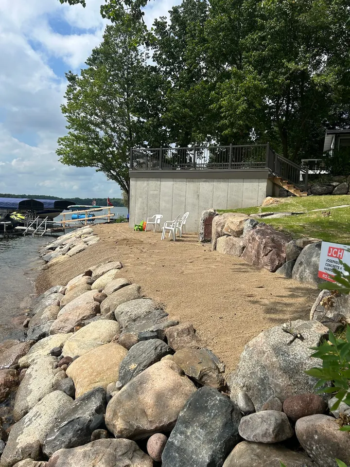
The clearest way to explain our method is a job we did on Lake Sylvia, the pair of deep lakes joined by a channel southwest of Annandale in western Wright County. The lot had a steep, bare slope running straight into the water. The bank was slumping toward the lake and the clay had nothing holding it. Here is what we did, in the order we did it, because the order matters.
- Compact equipment on the slope. We brought in a compact excavator that could work the hillside without tearing it up or sliding into the lake, graded the slope back, and cut a shelf at the base for the rock to key into.
- Filter layer. Before any rock, a filter of fabric or crushed rock goes down on the graded soil. Without it, waves pull fines out through the gaps in the rock, the riprap settles, and the bank fails behind a rock face that still looks fine from the dock.
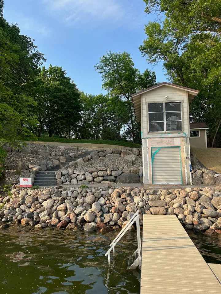
- Graded fieldstone at the waterline. We packed rounded natural fieldstone tight along the water's edge, sized to the wave exposure, on a slope no steeper than 3-to-1. The stone absorbs wave energy and holds the toe of the slope. This is the part that rides out ice push.
- Boulders set to stay. Up the bank we stacked large natural granite boulders into a retaining wall, each one seated on the one below with a lean back into the hill. These are sized and placed to carry the slope, not to decorate it.
- Seeded slope above. Above the wall, the regraded soil was seeded so roots take over the top of the bank. Rock holds the toe, the wall holds the hill, and grass holds the surface. That whole system is what stops the erosion cycle, and the granite tones sit naturally against the water instead of looking dropped in.
What drives the cost of shoreline and riprap work
We quote shoreline work after a site visit, because the price is set by the bank, not by a per-foot rate. These are the things that move it.
- Rock volume: the length of shoreline, how far the rock runs up the bank, and how thick the layer needs to be for the wave exposure on that lake.
- Access: whether a truck and a compact excavator can reach the water, or whether stone has to be moved by skid steer over mats, by hand, or from the water.
- Slope: a steep bank takes more grading, more rock to lay it back, and often a boulder wall above the riprap.
- Soil and water: saturated clay, springs in the bank, or a soft toe all take more base work.
- Permit work: a DNR public waters permit, a county land alteration permit, or watershed review adds time and drawings.
- Restoration above: seeding, erosion blanket, steps, or a path back up to the house.
When we would talk you out of it
- A bank with a house, septic system, or road sitting close to a tall failing slope, or one that is sliding in a deep rotational slump. That needs a geotechnical engineer to size the fix before anyone stacks rock. We will tell you so, and we will build to the engineer's design.
- A gentle, mostly stable shore with a thin buffer and light wave exposure. Native plantings and a restored buffer strip will hold it, the DNR prefers it, and it costs less. We will point you to that answer instead of quoting riprap.
- A lot where no equipment can reach the water: no easement, a slope too steep for a compact machine, or a lake that cannot take a barge. Hand-placed rock on a long bank is slow and the price shows it. Sometimes the honest answer is a smaller repair or a plantings-first approach.
How it goes
- 1
Call and describe the bank
Tell us the lake, how the bank is failing, and what sits above it. Photos from the dock looking back at the shore help a lot.
- 2
Site visit at the water
We walk the bank, look at wave exposure, ice marks, the OHWL, the soil, and how a machine gets down there. We talk through riprap, a wall, or plantings on the spot.
- 3
Written quote and permit plan
You get a written scope with the rock, the filter, the slope, and any wall, plus what we think the DNR and the county need for this parcel and who files what.
- 4
Build, seed, and clean up
We grade, lay the filter, set the stone and boulders, seed the slope, and leave the yard clean with the mats pulled and the ruts taken care of.
Questions we get asked
Do I need a DNR permit for riprap on my lake?
Usually not, if the riprap stays inside the DNR's standard: natural rock over a filter layer, no more than 6 feet waterward of the ordinary high water level, a slope no steeper than 3-to-1, under 200 feet of shore, and no cover over emergent plants. Outside those limits a public waters work permit is required. Check with the DNR area hydrologist for your lake before rock goes in, because a posted spawning area or a mapped floodplain changes the answer. Your county shoreland ordinance applies on top of this either way, and we walk through both with you at the site visit.
What is the ordinary high water level and why does it matter?
The ordinary high water level, or OHWL, is the elevation where the lake has sat long enough to leave a mark on the bank, usually where upland plants give way to water plants. It matters because it is the legal edge of public water. Below it the DNR regulates; above it your county's shoreland rules apply. Most riprap limits, like the 6 feet waterward and 10 feet landward rules, are measured from it, so we find that line on the site visit before we plan anything.
Riprap or a boulder wall: which one do I need?
Riprap fits a bank that can be laid back to 3-to-1 or flatter and takes waves or ice. A boulder wall fits a slope too steep to lay back, usually where a house, shed, or boathouse sits close to the water. Most steep lake lots get both: fieldstone at the waterline and boulders up the bank. A gentle, stable shore may need neither, just plantings and a buffer. We look at the slope and the wave exposure and tell you which one before we quote.
When is the best time of year for shoreline work?
Late summer and fall are usually easiest: the bank is at its driest, the lake tends to be down, and the mess is smallest. Spring works once the ground firms up, but high water and soft clay slow everything. We do not place rock across the ice. Permits can take weeks, so the best time to call is a season ahead of when you want the work done.
Will riprap hold up through ice push?
Properly built riprap does. Rock that is sized to the lake, laid on a 3-to-1 or flatter slope over a filter layer, and keyed into the toe of the bank moves as one mass when ice pushes against it, and settles back. What fails is loose rock dumped on a steep bank with nothing underneath. Filter fabric, a graded stone size, and a proper slope are what separate the two, and they are why we do not skip them to save a day.
Where we do this work
Shoreline and drainage across the towns around Cokato: Cokato, Dassel, Howard Lake, Annandale, Maple Lake, Buffalo, Delano, Hutchinson, Litchfield, Watertown, Winsted, Montrose. See the full service area.